
Public Usage of Conserved Lands
by Rick Allmendinger
If one of the CLC themes of summer of 2021 was Naming & Noticing, it also turned out to be a summer of counting. Because of concerns about overuse of the conserved lands in the Chocorua Lake Basin, we began to count cars visiting the Grove and hikers visiting the The Nature Conservancy’s Frank Bolles Nature Reserve. The data presented here is just the start of a long-term effort to measure patterns of public use of CLC and The Nature Conservancy (TNC) lands, so this article constitutes an initial progress report.
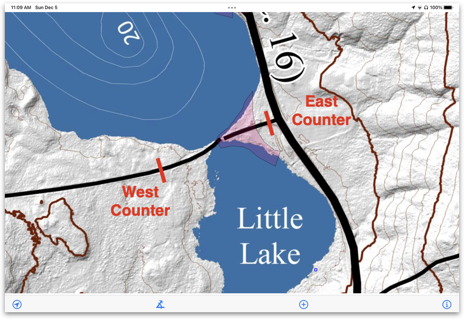
Traffic counter placement. Image courtesy of Rick Allmendinger
The CLC worked with Tamworth Road Agent Richard Roberts and the Lakes Region Planning Commission to design and deploy two traffic counters on Chocorua Lake Road, an eastern one at the entrance to the Grove near the intersection with Route 16 and a western one about 500 feet west of the Narrows Bridge for a week between July 27 and August 3. By subtracting the western counter from the eastern counter, we get a snapshot of summer 2021 usage of the Grove.

Traffic and precipitation by day during the summer monitoring period. Image courtesy of Rick Allmendinger
Here are some of the key findings:
The maximum number of cars visiting the Grove occurs between 11 and 3PM every day of the week. The highest traffic was on Saturday, July 31 when ~430 cars visited the Grove. On other days of the week, 240-300 cars visited the Grove. Thursday and Monday both had nearly an inch of rainfall but still recorded 200-260 visiting cars.
Traffic on the counter west of the bridge was consistently about 200 cars per day (some of those maybe the same car coming and going), except on Friday, Saturday, and Sunday when car counts rose to ~250-300. We assume that the rise is primarily due to weekend visits by property owners and renters, as well as some increase in traffic heading to the Liberty Trailhead.
In the one week of data collected, more than 5,700 cars turn onto, or off of Rt. 16 from/to Chocorua Lake Road. Rt. 16 at that intersection is in a 55-mile-per-hour speed zone and there is no turn lane or merging lane. This situation is a safety concern, one that could be ameliorated either by a turn lane or a reduced speed limit.
The counter data and an extended analysis, “Summary of Traffic Monitoring, Summer 2021,” can be found HERE.
Concern about overcrowding extended beyond use of the Grove to the trails north and west of the lake, especially around the fragile Heron Pond area. In response, The Nature Conservancy (TNC) deployed two trail counters, one on the Middle Trail and one on the Heron Pond Trail, in the Bolles Reserve. Michael Crawford, the TNC steward for the Bolles Reserve, reports that the Middle Trail counter recorded 170 visitors in the four months between July and November, an average of 1.3 people per day. It is probably less than that because a single person, walking out and back, would have been counted twice. As the Middle Trail is part of a frequent morning loop taken by the author of this piece, at least twenty of those counts were him and his wife on their morning walks through the Clark and Bolles preserves! Unfortunately, the Heron Pond Trail counter suffered water damage and the counts were unrecoverable. Overall, though, the existing counts point to low usage of the preserve, although the TNC is planning to deploy trail counters again on both trails in the summer of 2022.
The data from summer 2021 highlight the need for extended records of the usage patterns of the precious areas that we steward. The CLC experience in the summer of 2020 is part of a national trend of people rediscovering nature, taking walks and hikes, and enjoying swimming and paddling in beautiful pristine waters. Make no mistake: this is a good thing, especially when coupled with an awareness of how valuable and fragile these places are. By measuring usage patterns, we can begin to quantify actual, rather than anecdotal, use and impact and thus determine when these areas experience too much of a good thing. Good data is a key to developing strategies going forward. The CLC is in active discussions to develop a longer-term traffic measurement strategy. We welcome your feedback.
Banner image: Traffic counter placement. Image courtesy of Rick Allmendinger